Top Stories
Major Snowstorm Disrupts Travel in Midwest, Delays Expected
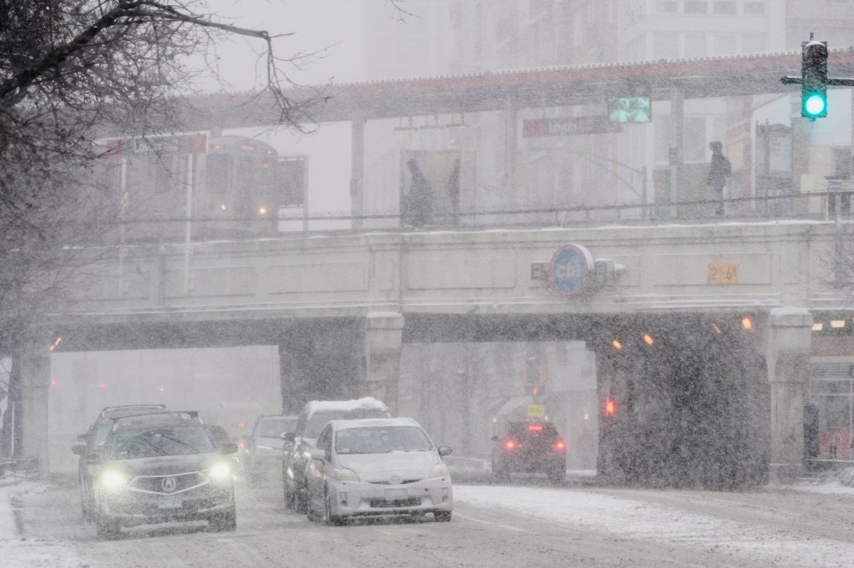
UPDATE: A powerful winter storm is currently battering the Midwest and Great Lakes region, severely impacting travel for millions of Americans returning home after Thanksgiving. As of Saturday morning, December 2, 2023, significant snowfall and treacherous road conditions have triggered major delays at airports, particularly in Chicago and St. Louis, where travelers are facing wait times of up to one hour.
The National Weather Service (NWS) has issued winter storm warnings and advisories stretching from Montana to Ohio. Reports indicate some areas could receive more than 8 inches of snow by end of the day, with northern Iowa already experiencing substantial accumulations. This storm hits during one of the busiest travel weekends of the year, making conditions even more critical for those on the road.
Officials report at least 45 vehicles were involved in crashes on westbound Interstate 70 near Terre Haute, Indiana, resulting in highway closures but thankfully no serious injuries. Forecasters warn that snowfall rates may exceed one inch per hour in several locations, including Chicago, Milwaukee, and Grand Rapids, creating hazardous conditions for both air and ground travel.
The storm’s effects are not confined to the Midwest. The same weather system is predicted to unleash thunderstorms and heavy rain from southern Missouri down to Louisiana and Texas. As the storm continues to develop, Wind-driven icicles are forming on Chicago’s piers, while motorists struggle to navigate slushy, snow-covered roads.
While no blizzard warnings are currently in effect, conditions are perilous.
“Stay home, have a nice cup of hot chocolate, watch some TV, play some games,”
advised Sheriff Del Garcia of Grant County, Indiana, emphasizing the need for caution during this severe weather.
Meteorologist Alyssa Glenny from AccuWeather highlighted that the regions most affected include cities within the six-to-twelve-inch snow bands, such as Des Moines and Chicago. “These locations are projected to face the heaviest snowfall rates, making travel dangerous,” she said.
Looking ahead, travelers should remain vigilant as the storm progresses and a potential second system approaches the Northeast early next week. Conditions on the roads are expected to stay hazardous throughout the weekend in the affected areas, with airport delays likely to persist as snow continues to fall.
As the storm unfolds, travelers are urged to monitor weather forecasts closely to avoid dangerous conditions. Stay tuned for more updates as this situation develops.

Community Unites to Attempt World Record for Largest Cookie Exchange

Mayor Lurie Appoints Alan Wong to District 4 Seat Amid Controversy

Mayor Appoints Alan Wong as New Supervisor for District 4

UK Report Reveals AI’s Role in Evaluating University Research Quality

Gabriela Jaquez Shines as No. 3 UCLA Dominates No. 14 Tennessee

Trump Promises to Release MRI Results Despite Uncertainty on Scan
Japan’s Q3 Capital Expenditure Slows Despite Surge in Profits
South Korea Announces Urgent FX Oversight Measures to Stabilize Won

Tampa’s Annual Tree Lighting Ignites Holiday Spirit Tonight

University of Hawaiʻi Joins $25.6M AI Initiative to Monitor Disasters

Toledo City League Announces Hall of Fame Inductees for 2024

DOJ Seizes $15 Billion in Bitcoin from Major Crypto Fraud Network

Sharp Launches Five New Aquos QLED 4K Ultra HD Smart TVs

Celtics Coach Joe Mazzulla Dominates Local Media in Scrimmage

Mutual Advisors LLC Increases Stake in SPDR Portfolio ETF

Community Unites for 7th Annual Walk to Raise Mental Health Awareness

Western Executives Confront Harsh Realities of China’s Manufacturing Edge

INK Entertainment Launches Exclusive Sofia Pop-Up at Virgin Hotels
-
Science4 weeks ago
University of Hawaiʻi Joins $25.6M AI Initiative to Monitor Disasters
-
 Lifestyle2 months ago
Toledo City League Announces Hall of Fame Inductees for 2024
-
 Business2 months ago
DOJ Seizes $15 Billion in Bitcoin from Major Crypto Fraud Network
-
 Top Stories2 months ago
Sharp Launches Five New Aquos QLED 4K Ultra HD Smart TVs
-
 Sports2 months ago
Celtics Coach Joe Mazzulla Dominates Local Media in Scrimmage
-
 Politics2 months ago
Mutual Advisors LLC Increases Stake in SPDR Portfolio ETF
-
 Health2 months ago
Community Unites for 7th Annual Walk to Raise Mental Health Awareness
-
 Science2 months ago
Western Executives Confront Harsh Realities of China’s Manufacturing Edge
-
 World2 months ago
INK Entertainment Launches Exclusive Sofia Pop-Up at Virgin Hotels
-

 Politics2 months ago
Major Networks Reject Pentagon’s New Reporting Guidelines
-

 Science1 month ago
Astronomers Discover Twin Cosmic Rings Dwarfing Galaxies
-

 Top Stories1 month ago
Randi Mahomes Launches Game Day Clothing Line with Chiefs