World
Hurricane Melissa Strikes Jamaica as Meteorologists Warn of Severe Impact
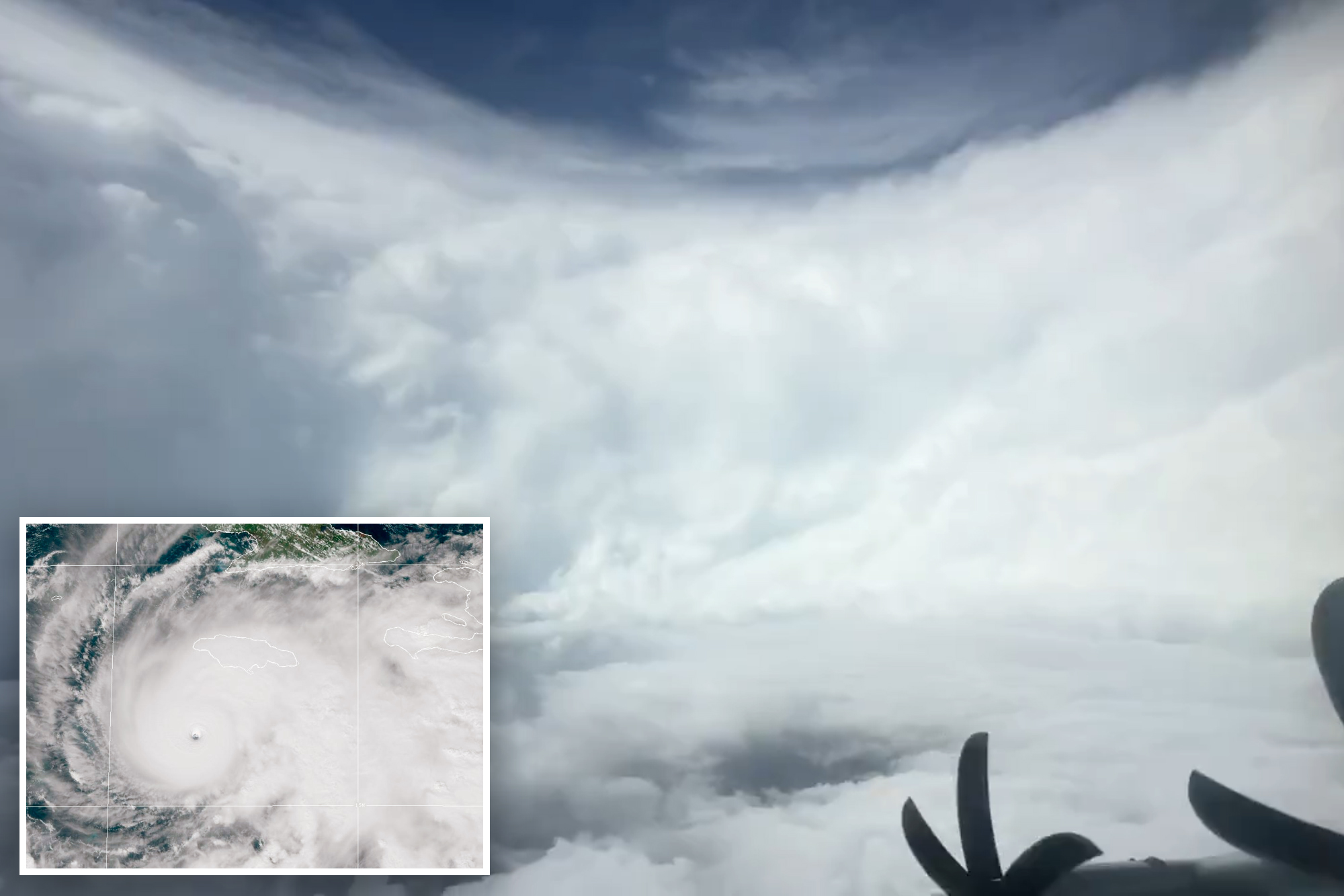
A powerful Category 5 hurricane, known as Hurricane Melissa, is poised to impact Jamaica with unprecedented force, featuring winds of nearly 200 mph. This storm is already being recognized as the most intense hurricane to approach the island since record-keeping began in 1850. The storm’s eye was captured in stunning footage by meteorologist Jeremy DeHart, showcasing a clear view of its cylindrical wall of clouds, which reaches heights of 10,000 feet.
On Sunday, DeHart shared the footage on X, noting, “As clear of an eye as you will see in the Atlantic basin.” Despite the violent winds of 175 mph swirling within its eyewall, the video revealed blue skies and sunshine above the storm’s towering clouds. Meteorologists anticipate Melissa will make landfall in Jamaica by Tuesday morning, bringing catastrophic conditions to the island.
Historically, Jamaica has faced significant storms, with Hurricane Gilbert in 1988 being the most damaging to date. That storm made landfall as a Category 3 hurricane, causing extensive damage to approximately one-fifth of Jamaica’s buildings, resulting in losses estimated at $2.5 billion and claiming the lives of 45 people. In stark contrast, Melissa’s projected winds of at least 150 mph indicate a far more severe threat.
Meteorologists from Fox Weather predict that all areas of Jamaica will feel the storm’s impact. According to meteorologist Greg Diamond, “Across western Jamaica, the eyewall’s 150-plus mph winds will have the potential to flatten buildings and cause extensive and long-lasting damage to all infrastructure in the area.”
The island could also receive up to 40 inches of rain, leading to catastrophic flooding and numerous landslides. As the storm progresses, it is expected to move past Jamaica by Wednesday, continuing to southeastern Cuba and then affecting Haiti, along with the Bahamas and Turks and Caicos, before heading out to sea.
Hurricane Melissa’s path suggests that it may enter the Atlantic by the end of Wednesday, potentially making its final landfall on Thursday in Bermuda. While the mainland United States, including Florida, is not expected to experience serious effects from Melissa, residents could face strong rip currents and rough seas along the panhandle.
As of Monday, Jamaica is already feeling the storm’s effects, with all airports on the island shut down and power lines beginning to fall due to the winds. Mandatory evacuations have been ordered in several areas, as storm surges are anticipated to reach heights of up to 13 feet, accompanied by severe flash flooding risks.
Authorities and meteorologists are closely monitoring Hurricane Melissa as it continues its dangerous trajectory, urging residents to heed warnings and prepare for a potentially devastating event.
Designers Unveil 5 Urgent Tricks to Transform Outdoor Eyesores

Shark Teeth Research Reveals Urgent Need to Protect Species

Church Members Unite in Resilience After Thanksgiving Fire

Community Unites to Attempt World Record for Largest Cookie Exchange

Mayor Lurie Appoints Alan Wong to District 4 Seat Amid Controversy

Mayor Appoints Alan Wong as New Supervisor for District 4

UK Report Reveals AI’s Role in Evaluating University Research Quality

Gabriela Jaquez Shines as No. 3 UCLA Dominates No. 14 Tennessee

Trump Promises to Release MRI Results Despite Uncertainty on Scan

University of Hawaiʻi Joins $25.6M AI Initiative to Monitor Disasters

Toledo City League Announces Hall of Fame Inductees for 2024

DOJ Seizes $15 Billion in Bitcoin from Major Crypto Fraud Network

Sharp Launches Five New Aquos QLED 4K Ultra HD Smart TVs

Celtics Coach Joe Mazzulla Dominates Local Media in Scrimmage

Mutual Advisors LLC Increases Stake in SPDR Portfolio ETF

Community Unites for 7th Annual Walk to Raise Mental Health Awareness

Western Executives Confront Harsh Realities of China’s Manufacturing Edge

INK Entertainment Launches Exclusive Sofia Pop-Up at Virgin Hotels
-
Science4 weeks ago
University of Hawaiʻi Joins $25.6M AI Initiative to Monitor Disasters
-
 Lifestyle2 months ago
Toledo City League Announces Hall of Fame Inductees for 2024
-
 Business2 months ago
DOJ Seizes $15 Billion in Bitcoin from Major Crypto Fraud Network
-
 Top Stories2 months ago
Sharp Launches Five New Aquos QLED 4K Ultra HD Smart TVs
-
 Sports2 months ago
Celtics Coach Joe Mazzulla Dominates Local Media in Scrimmage
-
 Politics2 months ago
Mutual Advisors LLC Increases Stake in SPDR Portfolio ETF
-
 Health2 months ago
Community Unites for 7th Annual Walk to Raise Mental Health Awareness
-
 Science2 months ago
Western Executives Confront Harsh Realities of China’s Manufacturing Edge
-
 World2 months ago
INK Entertainment Launches Exclusive Sofia Pop-Up at Virgin Hotels
-

 Politics2 months ago
Major Networks Reject Pentagon’s New Reporting Guidelines
-

 Science1 month ago
Astronomers Discover Twin Cosmic Rings Dwarfing Galaxies
-

 Top Stories1 month ago
Randi Mahomes Launches Game Day Clothing Line with Chiefs